Where exactly was the site of the original school? I think it was Newgate Street, wasn't it?
I have just read "Dark Fire" by CJ Sansom, which I would highly recommend. It is set in the year 1540, which we all know is too early for CH BUT there is a map in the front showing London at the time. There is a Christ's Hospital marked, apparently at least two buildings, just inside the city wall, on Newgate Street and just opposite Newgate Gaol. My dear husband says that it is hardly a unique name but .... is it our CH a few years early or something completely different? (It plays no part in the story)
I know I could probably find this information by a combination of Google and the books on my shelf, but I thought someone here might be interested or amused by this map.
London site of CH
Moderator: Moderators
-
Katharine
- Button Grecian
- Posts: 3325
- Joined: Mon Dec 26, 2005 10:44 pm
- Real Name: Katharine Dobson
- Location: Gwynedd
London site of CH
Katharine Dobson (Hills) 6.14, 1959 - 1965
-
mvgrogan

- Deputy Grecian
- Posts: 412
- Joined: Mon Sep 18, 2006 5:26 pm
- Real Name: Maria Vatanen (nee Grogan)
- Location: Turku, Finland
Re: London site of CH
can you scan it and add it here?
Maria Vatanen nee Grogan 6's (6:12) 81-85 BaB (BaB48) 85-87
-
sejintenej
- Button Grecian
- Posts: 4131
- Joined: Tue Feb 08, 2005 12:19 pm
- Real Name: David Brown ColA '52-'61
- Location: Essex
Re: London site of CH
Find the crossroads with Newgate Street running east to west.Katharine wrote:Where exactly was the site of the original school? I think it was Newgate Street, wasn't it?
I have just read "Dark Fire" by CJ Sansom, which I would highly recommend. It is set in the year 1540, which we all know is too early for CH BUT there is a map in the front showing London at the time. There is a Christ's Hospital marked, apparently at least two buildings, just inside the city wall, on Newgate Street and just opposite Newgate Gaol. My dear husband says that it is hardly a unique name but .... is it our CH a few years early or something completely different? (It plays no part in the story)
North west corner is St Sepulchre's Church to which the school marched/marches on St Matthews Day.
South west corner is a pub blown up by the IRA
South East corner is the Old Bailey (Central Criminal court), previously Newgate Goal.
North East corner there is a building and next to it in Newgate Street was the Post Office; there was a plaque about CH on it. CH had to have been bigger than that building but I am not sure which way it went. Not far behind, even in 1553 was and remains St Bartholemew's Hospital **- very very famous
As for the map being allegedly dated about 1540 I cannot comment. It COULD be that the institution was given (in 1553) a building already known by that name or it could be that the writer has used a later map to illustrate the area. Everything points to "our" institution being founded in 1553 - indeed (history being my major failing) I don't think that our founder was long out of nappies in 1540
I have to wonder about the reference to the City Wall at that location. The sovereign is forbidden to enter the City unless formally invited and she is stopped beside a statue of a lion in Newgate Street which is some way from the crossroads. It might be that the old wall was well inside the boundary of the City. There is an ancient (? Roman) wall some hundred yards to the east of the old CH building in Postmans' Garden
HTH
** I had the honour of reading the diary of a doctor and city councillor from Salvador da Bahia describing his visit to St Barts in the mid 1600's - interesting
-
NEILL THE NOTORIOUS

- Button Grecian
- Posts: 2612
- Joined: Sun Sep 14, 2008 10:01 pm
- Real Name: NEILL PURDIE EVANS
Re: London site of CH
We were given the Greyfriar's Monastry, as our School, but whether that was post, the actual Founding, it is, unfortunately, too late to ask anybody of that Era.
Certainly St Sepulchre's has a connection, It was from that Parish, that I got my Scholarship to CH, since my Father was working in that Parish at Snow Hill Police Station ! ---- If you are looking at old maps, that was the "Tabard Inn"
Certainly St Sepulchre's has a connection, It was from that Parish, that I got my Scholarship to CH, since my Father was working in that Parish at Snow Hill Police Station ! ---- If you are looking at old maps, that was the "Tabard Inn"
Re: London site of CH
Was there a Christ's Hospital in Newgate Street in 1540? The answer is a definite (well, 99.8percent) "no." I suspect that either the author, the publisher or the artist commissioned to produce a map simply found a map of that general era (presumably post-1553) and copied it without cross-checking dates and places. After all, the probability of a reader picking up an error must have seemed pretty remote - but that overlooked eagle-eyed Old Blues such as Katherine!

-
michael scuffil
- Button Grecian
- Posts: 1612
- Joined: Tue Oct 30, 2007 12:53 pm
- Real Name: michael scuffil
- Location: germany
Re: London site of CH
CH London was pretty vast. It occupied the quadrilateral between Newgate St (east end, opposite St Paul's), St Martins le Grand, Little Britain, and what on Google Maps is called Edward St (though I always thought it was King Edward St). Whatever it's called, it's the southern extremity of the A1, and Newgate St itself is the eastern extremity of the A40. The site is now occupied by the BT Centre. The main entrance was next to Christ Church in Newgate St, between the church and the churchyard, at the end of Christ Church Passage (facade now at the back of Big School). Christ Church was a Wren church that replaced the original Greyfriars' church, destroyed in the Fire. It acted as the school chapel until 1902. It was destroyed in the war, but the spire (one of Wren's best, go to google street view) was rebuilt, and the gutted church interior is now a garden. The parish of Christ Church was united with St Sepulchre at the other end of Newgate St, hence the present connexion. Of the original Greyfriars buildings, only what was called the "Giffs Cloister" (to be seen on many old prints and photos, it was semi-underground) survived until 1902. The rest was a hotchpotch of 17th, 18th and 19th century buildings, bits of which survive in places likely (CH Horsham) and unlikely (such as the marketplace in Beaminster, Dorset, which has the top of a tower. The town's Chamber of Trade has a simplified outline on its logo, and the structure itself can be seen, if you look hard, on the photo on the town's website.)
Th.B. 27 1955-63
-
NEILL THE NOTORIOUS
- Button Grecian
- Posts: 2612
- Joined: Sun Sep 14, 2008 10:01 pm
- Real Name: NEILL PURDIE EVANS
Re: London site of CH
WOW ! I should think that Michael Scuffi (Cartographer in Extremis ) has just about nailed it.
Fascinating stuff !
Fascinating stuff !
-
J.R.

- Forum Moderator
- Posts: 15835
- Joined: Wed Mar 09, 2005 4:53 pm
- Real Name: John Rutley
- Location: Dorking, Surrey
Re: London site of CH
Tony Robinson, Eat Your Heart Out !
John Rutley. Prep B & Coleridge B. 1958-1963.
-
Katharine
- Button Grecian
- Posts: 3325
- Joined: Mon Dec 26, 2005 10:44 pm
- Real Name: Katharine Dobson
- Location: Gwynedd
Re: London site of CH
I now have a scan of the map, but for various reasons I don't want to set up a photobucket account at the moment. Is there anyone willing to accept an email with an attachment, and then post it? If so, please email me so that I have your email.
Thanks
Thanks
Katharine Dobson (Hills) 6.14, 1959 - 1965
-
michael scuffil
- Button Grecian
- Posts: 1612
- Joined: Tue Oct 30, 2007 12:53 pm
- Real Name: michael scuffil
- Location: germany
Re: London site of CH
I am curious to know what bits of the London buildings are now at the Horsham site. The old entrance facade at the back of Big School, the arch of "Grecs Cloi" cut in half and now the cloister arches over the Avenue, the Big School organ -- but what else, if anything? Did the Fountain statue come from London? Aston Webb consciously made the Horsham buildings look a bit like the London ones, so it's a bit difficult to tell.
Th.B. 27 1955-63
-
mvgrogan
- Deputy Grecian
- Posts: 412
- Joined: Mon Sep 18, 2006 5:26 pm
- Real Name: Maria Vatanen (nee Grogan)
- Location: Turku, Finland
Re: London site of CH
I've emailled youKatharine wrote:I now have a scan of the map, but for various reasons I don't want to set up a photobucket account at the moment. Is there anyone willing to accept an email with an attachment, and then post it? If so, please email me so that I have your email.
Thanks
Maria Vatanen nee Grogan 6's (6:12) 81-85 BaB (BaB48) 85-87
-
mvgrogan
- Deputy Grecian
- Posts: 412
- Joined: Mon Sep 18, 2006 5:26 pm
- Real Name: Maria Vatanen (nee Grogan)
- Location: Turku, Finland
Re: London site of CH
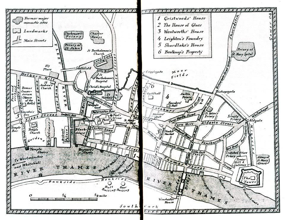
sorry about the size - if I reduce it, it's illegible! At least this is the right bit...
Maria Vatanen nee Grogan 6's (6:12) 81-85 BaB (BaB48) 85-87
-
Katharine
- Button Grecian
- Posts: 3325
- Joined: Mon Dec 26, 2005 10:44 pm
- Real Name: Katharine Dobson
- Location: Gwynedd
Re: London site of CH
I think you have probably got it right!Foureyes wrote:Was there a Christ's Hospital in Newgate Street in 1540? The answer is a definite (well, 99.8percent) "no." I suspect that either the author, the publisher or the artist commissioned to produce a map simply found a map of that general era (presumably post-1553) and copied it without cross-checking dates and places. After all, the probability of a reader picking up an error must have seemed pretty remote - but that overlooked eagle-eyed Old Blues
Thanks Maria, it is a pretty thick book, hence the shadow down the centre of the scan.
Katharine Dobson (Hills) 6.14, 1959 - 1965
-
michael scuffil
- Button Grecian
- Posts: 1612
- Joined: Tue Oct 30, 2007 12:53 pm
- Real Name: michael scuffil
- Location: germany
Re: London site of CH
My earlier post contains an error, for which see below.
My old tutor in Cambridge, Ron Gray, once wrote a piece about the OS Tourist Map of Cambridge for the Cambridge Review, entitled The Cambridge Nobody Knows, in which he said (among other things) that the cartographers seemed to be aiming for "chronological comprehensiveness" by including buildings already demolished. I think Katharine's map is chronologically comprehensive (i.e. anachronistic) in the opposite way, by including places not yet invented, while leaving out those already there, for while by 1540, Greyfriars had already been dissolved, its buildings were still there. That was the whole point of Bishop Ridley's famous sermon, namely that they were standing around uselessly.
Not on the map either is Christ Church Newgate St (then called the Greyfriars Church): perhaps the cartographer was anticipating the Blitz. But the Greyfriars Church which stood on the site was enormous, and had a public right of way running through its transept (after the Fire, when Wren built the much smaller Christ Church, this became Christ Church Passage).
My earlier error consisted in placing CH to the east, rather than the west, of King Edward St. (Christ Church stands on the north-west corner of the latter and Newgate St.) On the map, King Edward St (non-existent at the time) should be imagined about halfway between Aldersgate St and Pie Corner. Christ's Hospital started on Newgate St (within the Wall) and spread backwards, so its position on this map is certainly wrong geographically as well as chronologically. There is a description of the early buildings on p.48 of Pearce's Annals of Christ's Hospital; he says that the school in the early days was bounded on the north-west by the Wall, and later spread beyond it. This map is accurate in its placement of the Wall, at least.
Th.B. 27 1955-63
-
Katharine
- Button Grecian
- Posts: 3325
- Joined: Mon Dec 26, 2005 10:44 pm
- Real Name: Katharine Dobson
- Location: Gwynedd
Re: London site of CH
Thank you Michael for such an erudite reply, not that I would expect any less from you! I don't think I have Pearce's book, I inherited my father's collection but he did not have it, my brother wasn't interested in them.
Had the cartographer labelled those blocks on the map Greyfriars, it would have been consistent with the other former monastic sites - and not generated this discussion. As to missing out the church - I dunno! The Gaol does play a part in the story so perhaps it was decided not to have too much around it.
This is the second book in the series, both picked up at charity book stalls, the first is called Dissolution and is about the dissolution of a monastery (not Greyfriars) but the title appealed to this OB. I bought Dark Fire to read on our Christmas market trip (Liège, Aachen and Valkenburg this year), and found it a very good read. I'll keep my eye out for any more.
Katharine Dobson (Hills) 6.14, 1959 - 1965